Creating Sites
If sites cannot be imported, create them using the New Site page.
Locate the sites using Google Earth(TM) or Bing. Copy the latitude and longitude of each site.
To insert a Network Site in LINKPlanner, either click Project, New Network Site , or click New Network Site ![]() . To insert a Subscriber Site follow the same process selecting either New Subscriber Site or click the New Subscriber Site
. To insert a Subscriber Site follow the same process selecting either New Subscriber Site or click the New Subscriber Site ![]() . The appropriate New Network Site or New Subscriber Site page is displayed. The following process is the same for both types of site.
. The appropriate New Network Site or New Subscriber Site page is displayed. The following process is the same for both types of site.
The following is an example of a completed :ref: new_site page:
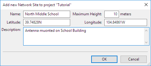
New Network Site Page
Name: Enter the site name.
Maximum Height: Enter the maximum antenna height (above ground) allowed at the site. The units are set in the Options/Preferences page (feet or meters).
Latitude and Longitude: The latitude and longitude must be in a format which can be understood and must use the WGS84 frame of reference. The following formats are supported:
Format Examples Decimal degrees prefixed by sign to indicate point of Compass:
‘+’ means North or East.
‘-‘ means South or West.
+12.34567
-12.34567
Decimal degrees and point of Compass. 12.34567N
12.34567E
Degrees, decimal minutes and point of compass. 12:34.567S Degrees, minutes, decimal seconds and point of compass. 12:34:56.7W UTM Reference (North/South hemisphere) and point of Compass:
First two numbers indicate UTM zone number
‘N’ after zone number means North hemisphere
‘S’ after zone number means South hemisphere
33N 453153.6E 3967848.3N
33S 453153.6E 3967848.3N
UTM Reference (with Latitude band) and point of Compass:
First two numbers indicate UTM zone number.
Third letter indicates Latitude band. There are such 20 latitude bands starting from ‘C’ at and increasing up the English alphabet until ‘X’, omitting the letters ‘I’ and ‘O’.
33S 453153.6E 3967848.3N MGRS Grid Reference
First three letters indicate Grid Zone Designations.33SVV5315367848

LINKPlanner stores site coordinates to 5 decimal places (~1m). If the coordinates are entered to a higher precision then the value will be rounded.
Description: Enter the site description.